A new severe weather threat is already emerging across the Central Plains, even before the current outbreak has fully ended. Forecast models are now pointing to another organized storm system expected to develop by Friday, April 17, 2026.
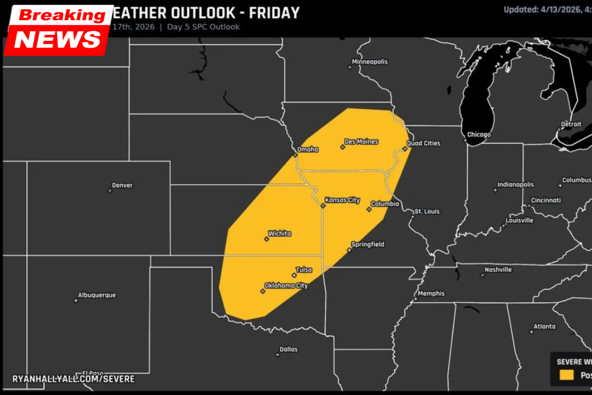
The Storm Prediction Center (SPC) has issued a Day 5 Outlook placing a Severe Weather Possible zone across a wide stretch of the Plains and Midwest. Cities including Oklahoma City, Tulsa, Wichita, Kansas City, Des Moines, and Omaha are all included in this early risk zone.
This early signal suggests that the atmosphere remains highly active, with little sign of settling down after multiple rounds of severe weather earlier in the week.
A Second System Already Taking Shape
Although the forecast is still five days out, meteorologists are paying close attention to this developing pattern. Seeing a clearly defined severe weather zone at this range is not routine and points to a strong and organized system forming.
The current data indicates that another round of storms could follow a similar path to earlier systems this week. This means areas already impacted may face renewed threats, increasing concerns about cumulative impacts.
Forecast confidence is still building, but the next 48 hours will be critical. As newer data becomes available, the outlook will become more precise, including details about storm intensity, timing, and specific hazards.
Areas Included in Friday’s Severe Weather Zone
The Day 5 outlook outlines a broad corridor of concern stretching from Oklahoma through parts of the Midwest.
| Area | Status for April 17 |
|---|---|
| Oklahoma City, Oklahoma | Inside risk zone |
| Tulsa, Oklahoma | Inside risk zone |
| Wichita, Kansas | Inside risk zone |
| Kansas City, Missouri | Inside risk zone |
| Columbia, Missouri | Inside risk zone |
| Springfield, Missouri | Inside risk zone |
| St. Louis, Missouri | Eastern edge |
| Des Moines, Iowa | Inside risk zone |
| Omaha, Nebraska | Inside risk zone |
| Quad Cities region | Inside risk zone |
| Dallas, Texas | Near southern edge |
| Minneapolis, Minnesota | North of zone |
| Chicago, Illinois | East of zone |
The core of this threat zone centers on the Kansas City–Wichita–Des Moines corridor, extending southwest toward Oklahoma and northeast into Nebraska and Iowa.
What “Severe Weather Possible” Means at Day 5
At the Day 5 stage, the SPC does not assign detailed categories like Slight or Enhanced risk. Instead, the “Severe Weather Possible” designation serves as an early alert.
This classification means:
- A storm system is expected to be present in the region
- Atmospheric conditions may support severe storm development
- Exact locations and intensity levels are still uncertain
- Future outlooks (Day 4 to Day 2) will refine the threat
- There is potential for risk upgrades as the event approaches
In simple terms, it is a heads-up rather than a final forecast. However, it is significant enough for both residents and emergency planners to begin monitoring closely.
A Relentless Pattern Across the Plains
This upcoming system is part of a larger, ongoing pattern affecting the central United States. Over the past several days, the same corridor has already experienced multiple rounds of severe weather.
Recent activity has included:
- A volatile supercell setup across Texas and Oklahoma earlier in the week
- An Enhanced Risk severe weather event stretching from Texas to the Great Lakes
- Continued storm activity across the Plains and Midwest
The repetition of storms over the same regions increases the risk of damage, especially in areas already affected. It also highlights a broader atmospheric setup that continues to favor storm development.
Cities That Should Monitor Conditions Closely
While details will evolve, several major population centers are currently positioned within the highest concern zone. Residents in these areas should stay alert over the coming days:
- Southern Plains: Oklahoma City, Tulsa, Wichita
- Missouri region: Kansas City, Columbia, Springfield, St. Louis
- Upper Midwest: Des Moines, Omaha, Quad Cities
These cities sit within the central axis of the forecast zone, making them the most likely to see refined and possibly increased risk levels as newer outlooks are issued.
Friday Outlook at a Glance
| Factor | Details |
|---|---|
| Date | Friday, April 17, 2026 |
| Outlook Type | SPC Day 5 |
| Last Updated | April 13, 2026 |
| Current Status | Severe Weather Possible |
| Core مناطق | Oklahoma to Iowa corridor |
| Confidence | Building |
| Upgrade Potential | High |
The developing storm system for April 17 is an early but important signal that the active weather pattern across the Central Plains is far from over. With multiple rounds of storms already impacting the region, this next system could add to an already challenging situation.
While it is still too early to determine the exact severity or impact, the presence of a clearly defined risk zone at Day 5 is enough to warrant attention. Residents across Oklahoma, Kansas, Missouri, Iowa, and Nebraska should stay informed as forecasts evolve.
Preparedness and early awareness will be key as meteorologists refine the outlook in the coming days.