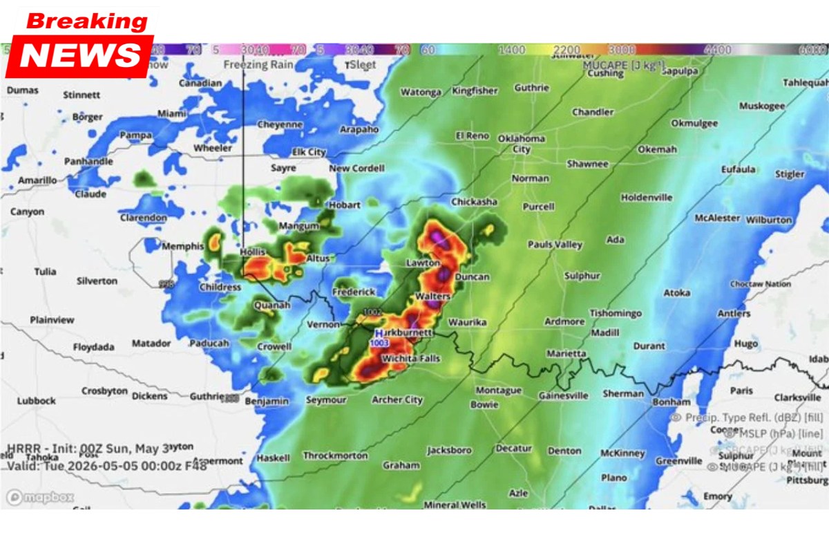
A dangerous severe weather setup is unfolding across southwest Oklahoma and north Texas on Monday, May 5, 2026, as a dryline sets the stage for potentially explosive storm development. If conditions align, there is a threat of tennis ball-sized hail, damaging wind gusts, and isolated tornadoes in the region.
Key Factors for Severe Weather: The Cap
The potential for severe storms in the area largely hinges on whether the atmospheric cap can be broken. A capping inversion is currently in place, but forecast models show increasing confidence that the cap will be broken, allowing for storm initiation.
This would trigger the development of supercell thunderstorms in a zone from Lawton, Oklahoma, to Wichita Falls, Texas.
The capping inversion is the critical factor; if it breaks, storms could quickly intensify, leading to the hazards described below. Surface-based CAPE values are particularly high, indicating the potential for strong storms if the cap can be overcome.
Severe Weather Hazards
If storms break the cap and develop, the following hazards are likely:
- Hail: Up to tennis ball size.
- Wind: Damaging gusts, potentially causing widespread property damage.
- Tornadoes: A couple of isolated tornadoes are possible.
Storm Initiation Zone
The most likely area for storm initiation is near Burkburnett, Walters, Vernon, and the Frederick to Lawton corridor across southwest Oklahoma and north Texas. Forecast models predict elevated MUCAPE values, which support storm sustenance if they develop.
In addition to this, storm-relative helicity values of 269 m²/s² and a well-defined LCL and LFC structure suggest that supercells could develop and produce severe weather, including tornadoes.
Forecast Confidence and Timing
While this severe weather threat is conditional, confidence in storm initiation is increasing. Forecasters are carefully monitoring the timing and location of potential storm development.
Confidence will continue to grow as the storm system evolves, and more refined forecasts will be issued as the situation becomes clearer on Monday afternoon.
What Residents Need to Know
Residents of southwest Oklahoma and north Texas should remain alert on Monday afternoon and evening. While the forecast remains conditional, it is critical to have a severe weather plan in place, including knowing where to take shelter if a tornado warning is issued. Stay informed with real-time updates as the situation develops.
Summary Table of Key Information
| Event | Details |
|---|---|
| Severe Weather Risk | Conditional Severe Weather (depends on breaking the cap) |
| Location | Southwest Oklahoma and North Texas (Burkburnett, Walters, Wichita Falls, Lawton corridor) |
| Timing | Monday afternoon into evening (May 5, 2026) |
| Hazards | Tennis ball-sized hail, damaging wind gusts, isolated tornadoes |
| Key Weather Factors | CAPE values, storm-relative helicity, LCL and LFC structure |
| Preparedness | Residents should stay alert and have a shelter plan ready |
Be Prepared for Changing Conditions
As the situation evolves, the potential for severe weather on May 5, 2026, across southwest Oklahoma and north Texas continues to develop. Storms capable of producing tennis ball-sized hail, damaging winds, and isolated tornadoes are possible if the cap can be broken. Stay informed and prepared for rapidly changing conditions throughout the day.