A dangerous severe weather event is unfolding on Saturday, April 14, 2026, with the Storm Prediction Center (SPC) warning of a heightened tornado threat in south-central and southeast Oklahoma, extending into parts of northeast Texas. The forecast indicates that supercells capable of producing powerful tornadoes, including those of EF3 strength or higher, could develop as early as 4 PM Central time.
Two Tornado Risk Zones: EF2+ and EF3+ Threats
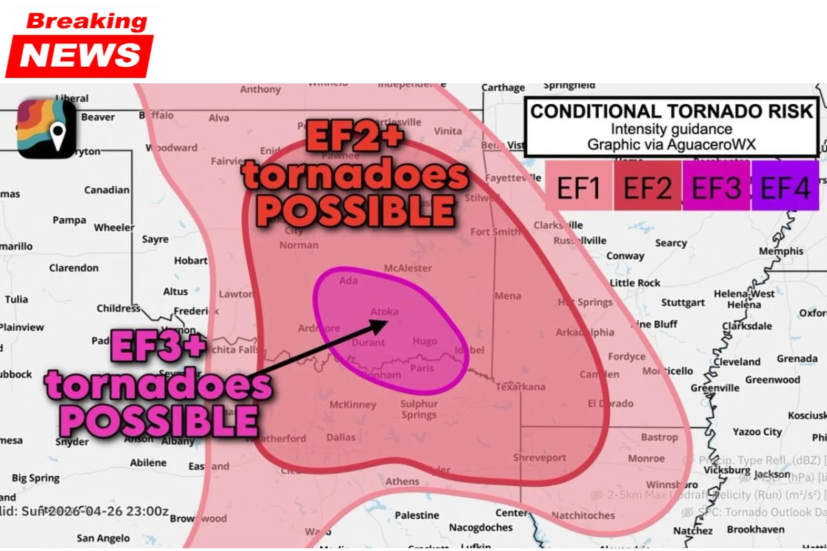
The tornado risk today is split into two distinct zones, each with different levels of severity:
- EF2+ Risk Zone (Larger Area):
A broad area stretching across central and eastern Oklahoma into northeast Texas is under an EF2 or greater tornado threat. This includes cities like Oklahoma City, Norman, McAlester, and Fort Smith. Tornadoes in this area could cause significant damage, especially to well-built homes, and pose a life-threatening risk to those without reinforced shelter. - EF3+ Risk Zone (Focused Area):
A smaller, highly concentrated area, including Ada, Atoka, Sulphur, Tishomingo, Madill, Colbert, Durant, Hugo, Antlers, and extending into Paris, Texas, faces the highest tornado threat. The SPC has indicated that the intensity of tornadoes in this zone could reach EF3 or even EF4 levels. EF3 tornadoes have wind speeds between 136 and 165 mph, while EF4 tornadoes exceed 166 mph, capable of devastating entire neighborhoods, overturning trains, and causing widespread destruction.
This particular area is being closely monitored due to extreme atmospheric conditions, making it the focal point for tornado development.
Critical Timing: 4 PM Central – The Peak of Tornado Threat
The most dangerous part of the storm system is expected to occur between 4 PM and 7 or 8 PM Central time. This is when supercells are likely to develop, taking advantage of the maximum surface instability that builds throughout the afternoon. The timing of this storm development coincides with the strengthening of the low-level jet, which helps create the wind shear necessary for tornado formation.
Residents in the EF3+ zone, including smaller communities such as Ada, Durant, and Hugo, are urged to act quickly before 3 PM to ensure they have a personal shelter plan in place. These areas, lacking the large emergency management infrastructure of major cities, face a very short lead time between storm initiation and the potential for tornado warnings. Waiting for sirens may be too late; shelters should be identified and prepared ahead of time.
Dual Threat: Tornadoes and Softball-Sized Hail
In addition to the tornado threat, the supercells expected to form will also produce extremely large hail, with softball-sized (4 inches in diameter) hail possible in the EF3 zone. A single storm with softball hail can cause millions of dollars in property damage in just minutes, as the massive hailstones smash through roofs, windows, and vehicles.
One of the most dangerous aspects of these storms is that hail and tornadoes can occur simultaneously from the same supercell. Seeking shelter from hail in a vehicle is a dangerous decision, as vehicle roofs offer no protection from either softball-sized hail or a tornado.
The Narrow Window Before Storms Merge
The tornado threat in southeastern Oklahoma is expected to remain highly concentrated in the discrete supercell phase from 4 PM to 7 or 8 PM. After this, storms are predicted to merge into a squall line, which will transition the threat from tornadoes to a wind-dominant storm system.
For the critical period before 7 PM, the focus will be on the isolated supercells that could produce powerful tornadoes. Once the storms merge into a squall line, the tornado risk will diminish, and the threat will shift towards strong winds and heavy rain.
Safety Measures for Communities in the EF3+ Zone
For communities like Ada, Atoka, Durant, and Hugo, many of which have a significant number of manufactured homes, the threat is particularly severe. Manufactured homes provide little protection against EF2 or stronger tornadoes. Therefore, residents are advised to find a permanent, more secure structure to shelter in before 4 PM and remain there when the storms arrive.
Avoid trying to outrun a tornado by vehicle, as the terrain in southeastern Oklahoma, with its numerous hills and limited roads, makes it extremely difficult and dangerous to escape a moving tornado.
Table: Key Details of the Tornado Threat
| Detail | Information |
|---|---|
| Tornado Risk Zones | EF2+ Zone (broad area), EF3+ Zone (focused area) |
| Cities in High-Risk Zone (EF3+) | Ada, Atoka, Sulphur, Tishomingo, Madill, Colbert, Durant, Hugo, Antlers, Paris (TX) |
| Tornado Intensity | EF3 (136-165 mph), possible EF4 (>166 mph) |
| Severe Hail | Softball-sized hail (4 inches in diameter) |
| Critical Timeframe | 4 PM to 7 or 8 PM Central |
| Primary Concern | Short lead times for tornado warnings, simultaneous hail and tornadoes |
| Communities at Risk | Smaller communities, especially those with manufactured homes |
| Safety Reminder | Find shelter before 4 PM, avoid vehicles for shelter during the storm |
Stay Prepared and Informed
As the tornado threat unfolds this afternoon, residents in the EF3+ zone should take immediate action to prepare for the possibility of severe weather. The combination of strong tornadoes, large hail, and the short lead times for warnings underscores the need for fast and effective shelter plans.
Stay updated on the latest weather developments through local news sources and trusted weather services. The storm system is expected to begin firing around 4 PM Central, so time is critical for those in the most dangerous areas.