Meteorologist Max Schuster is warning that the quiet stretches many people experienced earlier this spring are coming to an end. In their place, a much more dangerous and sustained severe weather pattern is setting up across the central and southern United States.
In his latest forecast, Schuster made it clear this is not just another round of storms. He described it as the beginning of a long-duration pattern that could bring seven straight days of meaningful severe weather, starting in the Great Plains and Midwest before shifting into Texas, Oklahoma, the lower Mississippi Valley, and Dixie Alley — and then reloading again.
Why A Multi-Day Pattern Is More Dangerous
Schuster stressed that extended stretches of severe weather are often more dangerous than a single outbreak.
Instead of preparing for one stormy evening, people may need to stay alert day after day as storms evolve, reorganize, and move into new areas. That repeated exposure increases the risk of fatigue, missed warnings, and cumulative damage.
He warned the pattern has all the ingredients for:
- Damaging winds between 50 and 70 mph
- Very large hail, possibly baseball-sized
- Multiple tornadoes, including strong ones
He also noted that some days later in the sequence could escalate into high-end severe weather events.
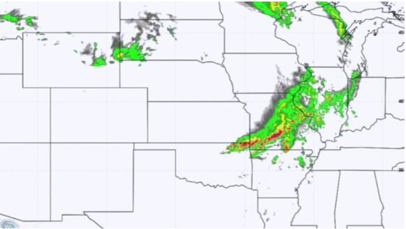
Thursday: Severe Weather Begins Across Plains and Midwest
The first major day arrives Thursday, with the Storm Prediction Center placing a slight risk from Minneapolis to Wichita, including Kansas City, Des Moines, and Omaha.
Schuster said the main threats include:
- Widespread damaging winds from Texas to northern Minnesota
- Very large hail in areas like Omaha, Wichita, Oklahoma City, and west of Dallas-Fort Worth
- A few strong tornadoes across a broad zone including Minneapolis, Des Moines, Tulsa, Oklahoma City, Wichita, and Kansas City
He highlighted the corridor between Wichita and Omaha as the most favorable for tornado development, though the risk extends farther south.
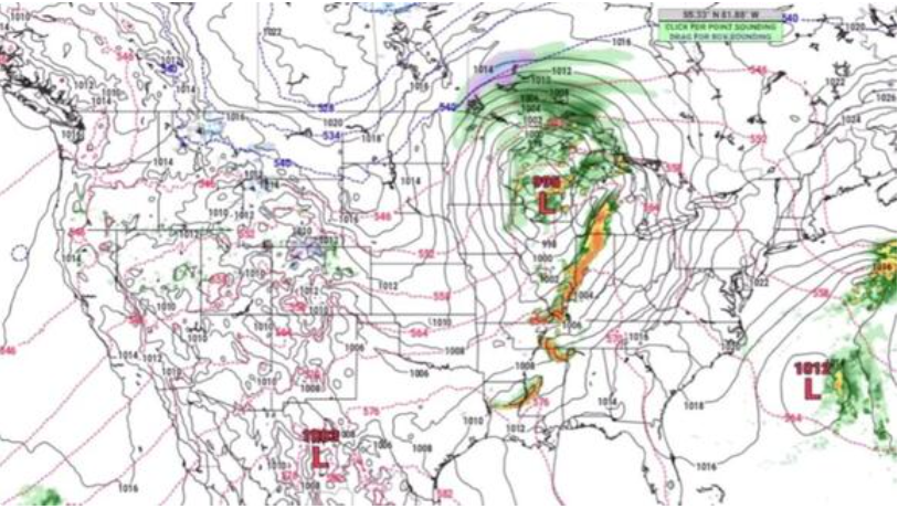
Storm Mode: The Key Factor for Thursday
One of Schuster’s biggest concerns is storm mode — how storms organize.
He pointed to the dry line stretching from western Iowa into Oklahoma as a critical zone. If storms form and remain isolated, especially in central Oklahoma, they could become strong, long-track tornado producers.
However, if storms cluster together, the threat may shift toward:
- Widespread damaging winds
- Embedded tornadoes
- Large hail
This distinction is important because large storm lines can cause more widespread destruction even if they don’t produce a single dominant tornado.
Friday: Severe Weather Shifts South and East
By Friday, the threat shifts into Missouri, Texas, Arkansas, and Tennessee, with cities like Springfield, Dallas, Shreveport, and Memphis in focus.
Schuster described Friday as uncertain, calling it a “50/50 day.”
Two scenarios are possible:
- A lingering overnight storm line continues producing severe weather
- Or that line weakens, allowing new supercells to develop later in the day
If new storms form near Fort Smith or west of Little Rock, they could bring a more concentrated hail and tornado threat.
Saturday: Enhanced Risk Returns to Oklahoma and Kansas
The pattern reloads Saturday as a new system moves out of the Rockies.
An enhanced risk is already outlined for:
- Wichita
- Tulsa
- Oklahoma City
A broader slight risk extends into Dallas and central Kansas.
Schuster expects:
- Bowing storm segments producing strong winds
- QLCS tornadoes embedded within storm lines
- Continued hail risk
These fast-moving storm lines can cause widespread damage and are often harder for people to track visually.
Sunday: Potential High-End Tornado Setup
Sunday stands out as one of the most concerning days.
Schuster said the setup includes:
- A dry line configuration
- Strong instability
- Multiple supercells
This combination could support a major severe weather event with strong tornadoes.
However, uncertainty remains due to the “cap,” a layer that can prevent storms from forming. If storms break through, the situation could escalate quickly.
This makes Sunday a day forecasters will monitor closely right up to the last minute.
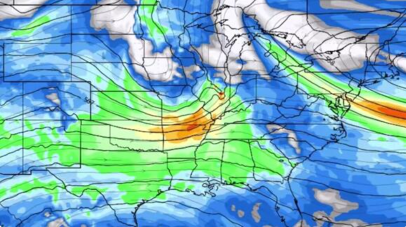
Monday: Expanding Threat Across a Wider Region
Monday could become even broader in impact.
Schuster noted newer models suggest a storm system tracking farther north and west, potentially expanding the threat zone from:
- Chicago and Michigan
- Down into the lower Mississippi Valley
He compared this setup to a past event featuring:
- Widespread damaging winds
- Embedded tornadoes
He expects the Storm Prediction Center may eventually introduce an enhanced risk.
A Dangerous Factor: Quiet Start to 2026
Schuster pointed out that many areas, especially in the South, have seen little severe weather so far this year.
That quiet start can lead to reduced preparedness, making a sudden active period feel more dangerous.
Pattern Likely Continues Beyond Monday
The severe weather pattern may not end after Monday.
Schuster expects:
- Storms lingering into Tuesday morning
- Another system developing Tuesday into Wednesday
- Continued activity across the Plains
Looking ahead to early May, some models suggest a brief slowdown in the Midwest, but the Plains from Texas to Nebraska could see severe weather ramp up “in a big way.”
A Sustained and High-Risk Weather Pattern
What makes this forecast especially serious is its duration.
This is not a single outbreak — it is a repeating cycle of severe weather systems that could impact multiple regions over an entire week.
Schuster’s warning is clear:
- Expect repeated rounds of storms
- Prepare for multiple days of risk
- Stay alert even after one system passes
Because in this kind of pattern, the next storm is often already forming before the last one is gone.