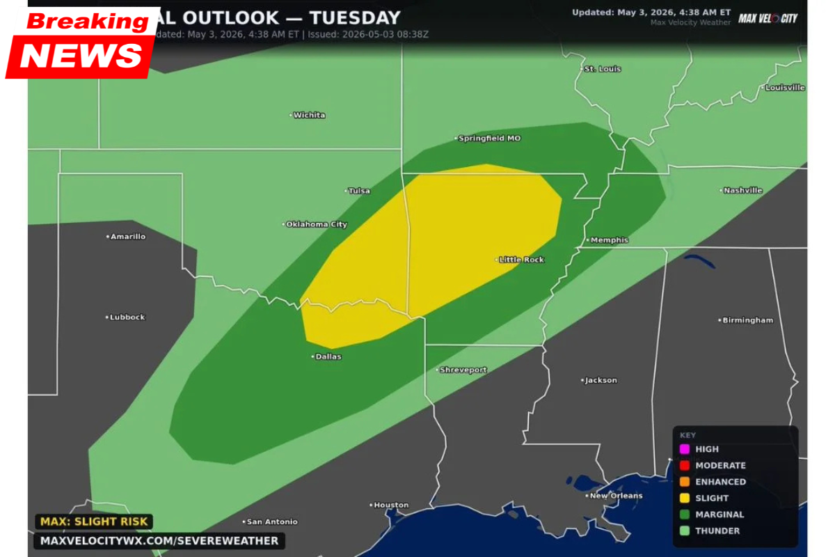
A Slight Risk severe weather outbreak is forecast for Tuesday, May 5, 2026, with dangerous conditions expected across a wide corridor stretching from Dallas, Texas, to Memphis, Tennessee. Supercells capable of producing very large hail, damaging winds, and tornadoes are expected to develop in the afternoon and evening hours, impacting a large portion of the central United States.
Slight Risk Zone: Affected Areas
The Slight Risk zone is centered over a corridor running from north Texas and Oklahoma City, northeast through Tulsa, Little Rock, and up to Memphis. This zone represents the area where severe weather is most likely to occur, particularly in the form of supercell thunderstorms.
Additionally, a broader Marginal Risk area extends beyond the Slight Risk zone, covering cities such as Springfield, MO, Nashville, Jackson, Shreveport, and Houston, where the general threat of storms remains but with slightly lower intensity.
Hazards Expected Within the Slight Risk Zone
The primary hazards within the Slight Risk zone on Tuesday are as follows:
- Hail: Very large hail is possible, especially with supercell thunderstorms.
- Wind: Damaging wind gusts are expected, potentially causing significant property damage.
- Tornadoes: A couple of tornadoes are possible, with the highest likelihood in the central corridor of the Slight Risk zone.
- Timing: The severe weather is expected to develop primarily during the afternoon and evening hours on Tuesday, with supercell thunderstorms tracking northeast through the risk corridor.
Cities Impacted
- Dallas, TX
- Oklahoma City, OK
- Tulsa, OK
- Little Rock, AR
- Memphis, TN
- Shreveport, LA
Precautionary Measures
Residents in the Slight Risk zone should prepare for severe weather by having their severe weather plans in place before Tuesday afternoon. This includes staying informed, having access to weather alerts, and knowing where to take shelter if a tornado warning is issued.
Summary Table of Key Information
| Event | Details |
|---|---|
| Severe Weather Risk | Slight Risk (supercells, large hail, wind, tornadoes) |
| Timeframe | Afternoon into evening, Tuesday, May 5, 2026 |
| Main Hazards | Large hail, damaging winds, tornadoes |
| Primary Impact Areas | Dallas, Oklahoma City, Tulsa, Little Rock, Memphis, Shreveport |
| Additional Risk Areas | Springfield MO, Nashville, Jackson, Shreveport, Houston |
Stay Prepared for Severe Weather
The upcoming severe weather event could bring significant hazards to residents across parts of Texas, Oklahoma, Arkansas, and Tennessee. Keep an eye on the weather throughout the day and remain alert for warnings issued by the National Weather Service. For live updates, stay with CabarrusWeekly.com as we cover the severe weather outbreak on Tuesday.