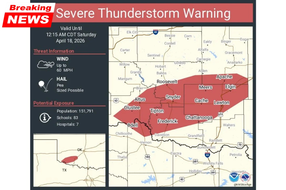
A Severe Thunderstorm Warning is currently in effect for parts of southwestern Oklahoma, including Lawton, Altus, and Frederick. The warning remains active until 12:15 a.m. Central Time, impacting approximately 151,791 residents, along with schools, hospitals, and critical infrastructure across the region.
The storm system is producing dangerous conditions, including wind gusts up to 60 mph and hail, posing an immediate risk to property and safety.
Areas Impacted by the Storm
The warning spans across multiple counties in southwestern Oklahoma, including Comanche County, Tillman County, and Kiowa County.
Communities currently under the warning include:
- Lawton, the largest population center in the path of the storm
- Altus, on the western edge of the storm system
- Frederick, near the Texas border
- Snyder, Cache, and Meers in the central corridor
- Tipton, Chattanooga, and Olustee in southern areas
- Apache and Elgin along the eastern edge
- Roosevelt in the northern portion of the warning zone
These areas are experiencing or are about to experience severe weather conditions as the storm moves northeast.
Primary Threats: Wind and Hail
This storm carries two main hazards that require immediate attention.
Strong Winds: Gusts reaching up to 60 mph are capable of causing significant damage. Trees may be uprooted or lose large branches, power lines can be downed, and unsecured outdoor objects may become dangerous projectiles.
Hail: Pea-sized hail is being reported across the region. While smaller than hail seen in other recent storms, it can still damage vehicles, windows, and create hazardous road conditions.
With nearly 152,000 people inside the warning area, including several hospitals and dozens of schools, the storm’s impact is widespread.
Why Severe Weather Is Developing
The storms are part of a larger weather system moving across the central United States. While the most intense tornado activity has been focused further north, the southern portion of the system continues to generate severe thunderstorms.
Southwestern Oklahoma sits along the trailing edge of a cold front pushing southeast through the Southern Plains. This interaction—combined with a dryline—creates conditions favorable for strong nighttime storms.
This type of overnight severe weather is not unusual for the region during spring, but the strength and coverage of this storm make it particularly dangerous.
Safety Actions Residents Should Take
Residents in affected areas should act immediately to reduce risk.
- Move indoors and stay away from windows
- Secure or bring inside any outdoor items
- Avoid travel, especially on open roads where wind gusts are strongest
- Stay in a sturdy structure until the warning expires
- Continue monitoring weather updates after 12:15 a.m. in case additional storms develop
For those in Lawton, Altus, and Frederick, conditions are either ongoing or imminent, making immediate shelter essential.
Summary of Key Information
| Aspect | Details |
|---|---|
| Warning Type | Severe Thunderstorm Warning |
| Expiration Time | 12:15 a.m. Central Time |
| Major Cities Affected | Lawton, Altus, Frederick |
| Counties Impacted | Comanche, Tillman, Kiowa |
| Population Affected | Approximately 151,791 residents |
| Main Threats | 60 mph wind gusts, pea-sized hail |
| Infrastructure at Risk | 83 schools, 7 hospitals |
| Storm Cause | Cold front and dryline interaction |
This severe thunderstorm warning highlights the ongoing risks associated with spring weather patterns in Oklahoma. While not as extreme as recent tornado outbreaks elsewhere, the combination of strong winds and hail presents a serious threat to life and property.
Residents are urged to take the warning seriously, remain indoors, and stay alert for further updates. Even after the current storm passes, additional activity may develop overnight, making continued vigilance essential.