A prolonged stretch of dangerous weather is expected to continue across parts of the Southern Plains and Midwest on Tuesday, May 19, 2026, as forecasters warn of damaging winds, large hail and possible tornadoes.
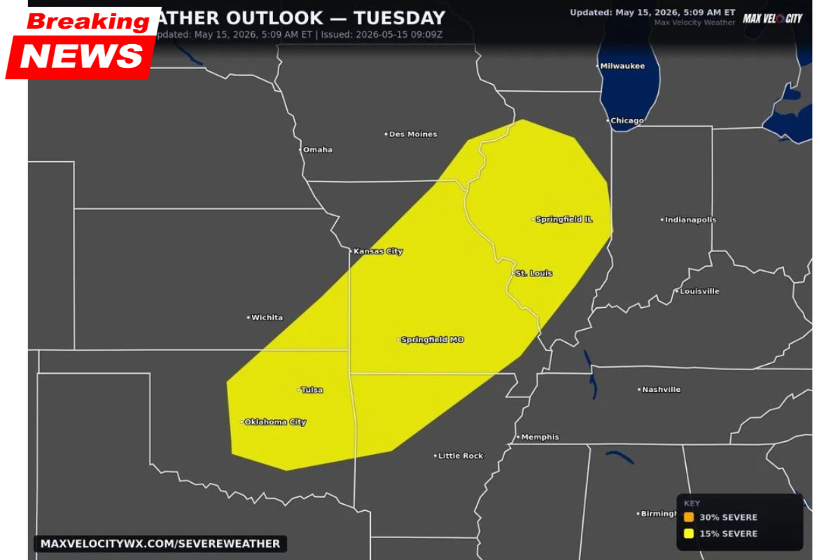
The latest severe weather outlook, updated early May 15, shows a broad risk corridor stretching from Oklahoma through Missouri and into parts of Illinois. Meteorologists say the system could mark at least the fifth consecutive day of severe weather activity across the region.
Residents in multiple states are being urged to stay alert as conditions remain favorable for strong thunderstorms and rapidly changing weather patterns.
| Key Detail | Information |
|---|---|
| Date of Threat | May 19, 2026 |
| Main Regions Impacted | Southern Plains and Midwest |
| Main Hazards | Damaging winds, hail, tornadoes |
| Risk Level | 15% severe weather risk |
| Major Cities Included | Oklahoma City, Kansas City, St. Louis |
| Weather Pattern Duration | At least 5 consecutive days |
| Peak Concern | Strong thunderstorms |
Areas Included in Tuesday’s Severe Weather Risk
The updated outlook places several major cities within the active severe weather corridor.
Areas facing the greatest threat include:
- Oklahoma City
- Tulsa
- Kansas City
- St. Louis
- Springfield
- Springfield
- Little Rock
- Memphis
Forecasters say the risk area forms a large southwest-to-northeast corridor where atmospheric instability and strong storm development are expected.
Several nearby cities, including Chicago, Milwaukee and Indianapolis, currently remain outside the main Tuesday threat zone.
Main Severe Weather Hazards Expected
Meteorologists say damaging straight-line winds are expected to be the primary threat across much of the region.
Strong thunderstorm systems could produce:
- Wind gusts capable of damaging buildings and power lines
- Large hail with stronger storm cells
- Isolated tornadoes in areas with favorable rotation
The combination of unstable air, moisture and upper-level weather dynamics could allow storms to intensify rapidly during the afternoon and evening hours.
Forecasters are closely monitoring the potential for supercell thunderstorm development in portions of Oklahoma and Missouri.
One of the Longest Severe Weather Stretches of 2026
Tuesday’s weather threat continues a highly active severe weather pattern that has already impacted large portions of the Plains and Midwest earlier in the week.
Weather experts say this sequence could become one of the longest uninterrupted severe weather periods of the 2026 spring season.
Multiple rounds of storms over several days increase the risk of:
- Flash flooding
- Power outages
- Wind damage
- Repeated severe thunderstorm warnings
- Tornado emergencies in isolated areas
Communities already affected by earlier storms may face additional hazards if new systems move over saturated ground and damaged infrastructure.
Why the Severe Weather Pattern Is Continuing
Meteorologists say the ongoing severe weather outbreak is being fueled by a combination of warm Gulf moisture, unstable air masses and repeated storm systems moving across the central United States.
Spring weather patterns commonly create strong thunderstorm environments across the Plains and Midwest, but prolonged stretches lasting several consecutive days are less common.
The setup allows storm systems to repeatedly redevelop across similar areas, increasing both storm intensity and overall weather fatigue among residents.
Safety Precautions for Residents
Officials encourage residents in the affected regions to remain weather-aware throughout the week.
Safety recommendations include:
- Monitor local weather alerts regularly
- Keep phones and emergency radios charged
- Identify safe shelter locations in advance
- Avoid traveling during severe storms if possible
- Prepare for potential power outages
Residents in tornado-prone regions are also advised to review emergency plans and know where to seek shelter quickly if warnings are issued.
Travel and Infrastructure Concerns
The prolonged severe weather pattern could also disrupt transportation and daily activities across multiple states.
Possible impacts include:
- Flight delays and cancellations
- Road flooding
- Downed trees and power lines
- Hazardous driving conditions
- Damage to homes and businesses
Utility crews and emergency responders across the region may remain on high alert as storms continue developing over the coming days.